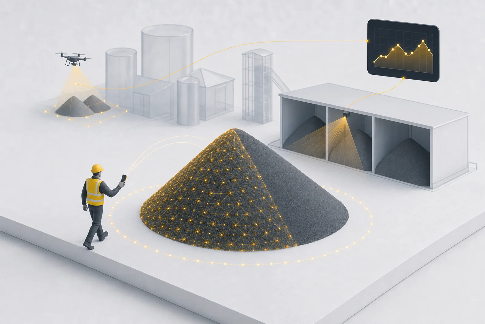
The short answer: it comes down to how your inventory lives. If you need one-off measurements, or your piles move, come and go, or sit at sites without infrastructure, mobile capture is the answer: one lap around the pile with your phone gets within a few percent of a professional survey. No hardware, no pilots, no installation. If your storage is fixed and the numbers run the business, meaning you want exact inventory at any moment, runout projections, and every delivery and consumption event on a timeline, continuous monitoring with fixed sensors is the answer, and it's the one option in this comparison nothing else can imitate. Drones still earn their keep for scheduled audits of large open sites. The traditional walk-around formula runs ±20–40%, which is why auditors stopped accepting it.
Here's the whole landscape: where each method wins, where it breaks down, and which products are worth your time.
The quick verdict
| Your situation | Best method |
|---|---|
| Piles measured weekly, monthly, or quarterly | Phone scanning app |
| Remote or satellite sites with no infrastructure | Phone scanning app |
| Temporary, seasonal, or moving inventory (laydown yards, project sites) | Phone scanning app |
| Checking inventory between scheduled drone audits | Phone scanning app |
| Large open quarry or aggregate yard, many piles at once | Drone photogrammetry |
| Sheds, bays, and bunkers with daily throughput (the storage that runs your P&L) | Fixed LiDAR sensors (continuous) |
| Enclosed silos and tanks | Level sensors or scheduled scans |
| A one-time number for a dispute or audit | Professional laser-scanning survey |
| A rough gut check right now | Walk-around + formula (accept ±20–40%) |
Method 1: The walk-around estimate
The oldest stockpile measurement method: pace off the base, eyeball the height, and apply the cone formula, volume = (π × r² × h) ÷ 3. Elongated piles get the windrow variant. Multiply by material density for tonnage, or skip the arithmetic and use our free stockpile volume calculator.
Where it works: quick sanity checks, small piles, materials where being 30% off doesn't matter.
Where it breaks: everywhere else. Real piles have scalloped faces from loader cuts, uneven crowns, and sloped bases. The formulas assume geometry your yard doesn't have. Typical error is ±20–40%, and it compounds: a 30% volume error on a 3,000-ton pile is a 900-ton accounting surprise at month-end. If your inventory feeds a balance sheet, a walk-around estimate is a liability, not a measurement.
Method 2: Phone scanning apps, the new default for periodic measurement
Modern phones carry enough sensing to do real photogrammetry (and on Pro iPhones, LiDAR). Stockpile measurement apps use them to build a 3D model of the pile as you walk around it, then compute volume against a detected base plane. A measurement is one lap around the pile, a couple of minutes on a typical pile, and a well-captured scan lands within a few percent of a professional survey. A different universe from the walk-around estimate, at less effort: you were going to walk past the pile anyway.
The category splits into two shapes:
- Standalone measurement apps. SR Measure (Stockpile Reports) is the longest-standing example. You scan a pile, you get a number. Fine as far as it goes, but every measurement lives in that app, and getting it into your inventory records, month-end close, or customer reports is your problem.
- Capture into a platform. This is how Rebulk mobile capture works: the phone is one capture source among several, and every scan lands in the same inventory system as your drone flights and fixed sensors. One record per pile with the full 3D model behind every number, so operations, accounting, and customers are all looking at the same figure instead of three spreadsheets that almost agree. Scans work with or without phone LiDAR (photogrammetry covers non-Pro phones).
The difference sounds subtle until month-end. A measurement that lives in an app silo is a photo of your inventory; a measurement that lands in your system of record is your inventory.
Where mobile capture is the right answer, not a compromise:
- Between drone audits. A monthly drone survey gives you twelve accurate days a year. A phone scan any time a pile looks off (after a big haul-out, before a customer call, at month-end) fills the other 353 days without scheduling a pilot. Drone-plus-phone is quietly becoming the standard cadence: fly for the full-site audit, scan for everything in between.
- Remote and satellite sites. A gravel pit two hours out, a leased laydown yard, a customer's terminal: places nobody will ever install hardware and no drone program will ever cover economically. Someone already drives there; now their phone is the measurement infrastructure.
- Moving and temporary inventory. Project stockpiles, seasonal salt, staging piles that exist for six weeks. Inventory that relocates makes fixed anything pointless. The sensor should travel with the person, not bolt to the building.
- Day-one adoption. No CapEx approval, no install crew, no pilot certification. The crew you already have, measuring accurately this afternoon.
Where phone scanning genuinely breaks: capture discipline matters (you need to actually walk the pile and keep it in frame), and very large piles, think several hundred feet long, get slow to walk and are better flown. Occluded back faces against walls reduce confidence.
Honest take: this is the best effort-to-accuracy ratio in the industry, and for distributed, moving, or periodically-measured inventory it's not the budget option. It's the correct one.
Want to see for yourself? Get early access to Rebulk mobile capture and scan one of your own piles this afternoon.
Method 3: Drone photogrammetry for big, open sites
Drone stockpile measurement flies a grid over the site, captures hundreds of overlapping photos, and reconstructs the whole yard as a 3D surface. With ground control points, accuracy on well-defined piles is in the 1–2% range, and one flight measures every pile on the site at once.
DroneDeploy and Propeller are the established platforms here (either paired with DJI hardware is the common stack); Pix4D is the general-purpose photogrammetry engine many surveyors use. All are good products. This is also what most third-party stockpile survey services are selling: a pilot, a flight, and a report.
Where drones break:
- Indoors is a hard no. Sheds, domes, and bunkers, where a huge share of real bulk inventory actually lives, can't be flown.
- It's a program, not an app. In the US you need a Part 107-certified pilot, flight planning, weather windows, and processing time. Sites typically end up on monthly or quarterly cadence because each survey has real cost.
- It's a snapshot. The number is right for the hour you flew. What happened between flights is interpolation.
Honest take: the right tool for large open quarries and aggregate yards, and we say that as a company that also offers drone capture as a service. Just don't expect a drone program to cover your covered storage, or your Tuesdays.
Method 4: Fixed LiDAR, the only method that never stops measuring
Every method above shares one property: it's a one-off scan. You get a true number for a moment in time, then uncertainty grows until the next measurement. Shrink, mis-loads, and reconciliation gaps live in the space between scans.
Fixed LiDAR sensors invert the model. Mounted overhead in a shed, on a pole in a yard, or across a row of bays, they re-measure the pile continuously: every load in, every bucket out. Inventory stops being a snapshot you take and becomes a fact you can look up:
- A live number, always. Current volume for every bay on a dashboard, not a figure from three weeks ago plus hope.
- A change history with timestamps. The 2 a.m. haul-out is a step change on a chart, not a month-end mystery nobody can reconstruct.
- Alerts when something moves that shouldn't. The difference between measuring inventory and actually watching it.
- Month-end that's already done. When the pile has been measured continuously all month, the close is a report, not a field exercise.
- One number everyone shares. Operations, accounting, and the customer whose material sits in your bay all see the same live figure. That's the single-source-of-truth idea taken to its logical end.
This is the Rebulk system's home turf, and it's worth being direct about the competitive landscape: the drone platforms sell you flights, the measurement apps sell you scans, and nobody else in this comparison offers a continuous option at all. If your operation has storage where the daily numbers actually run the business (a transload terminal, a shed with multiple material owners, bays that turn over every day), continuous measurement isn't an upgrade to scanning. It's a different category of knowing.
Where fixed sensors break: they're an installation with real cost, and they earn it where material stays put and moves often. Remote pits, temporary laydown piles, and quarterly-audited yards are better served by the phone in your pocket. That's exactly why they're capture sources in the same platform, not competing products.
Method 5: The specialists
- Professional laser-scanning surveys. A surveyor with a terrestrial scanner produces a defensible, stamped number. Right for disputes, acquisitions, and annual audits; overkill (and too slow) for operations.
- Silo and bin level sensors. Radar or ultrasonic probes for fully enclosed vessels. They read one point (or a small scan cone) rather than a true surface, which is fine for tall, self-leveling materials and rough for anything that bridges, rat-holes, or piles unevenly.
The real variable is measurement frequency
Every measurement is accurate the moment you take it. Then uncertainty grows until the next one. A quarterly survey means four trustworthy days a year. If material walks off site the week after your drone flight, you find out at the next flight, as an unexplained variance nobody can trace anymore.
The traditional fix was expensive: fly more often, hire more surveys. The actual fix is making each measurement so cheap you can take one whenever the risk warrants it. That's the quiet revolution in phone-based capture. It collapses the marginal cost of a real measurement to one lap around the pile, so cadence can finally match reality: scan after the big haul-out, scan before the customer call, scan because the pile looks smaller than it should.
The pattern we see working across sites is layered: drones for the scheduled full-site audit, phone scans for everything that happens in between, and fixed sensors only on the specific storage where daily throughput justifies watching it 24/7. Frequency where you need it, hardware only where it pays.
The layering only works if everything lands in one place. When the drone survey, the Tuesday phone scan, and the sensor feed each live in their own tool, you haven't solved inventory. You've tripled the reconciliation. The end state worth building toward is a single source of truth: every capture method writing to one record per pile, so the number operations manages, accounting closes on, and customers get invoiced from is the same number.
FAQ
How accurate is phone-based stockpile measurement? A well-captured phone scan is typically within a few percent of a professional survey, versus ±20–40% for walk-around estimates. Capture quality is the main variable: walk the full perimeter, keep the pile in frame, and don't rush.
Can a drone measure piles inside a shed or dome? No. GPS loss and confined spaces make indoor flight impractical for surveying. Indoor and covered storage is measured with phone scans, terrestrial scanners, or fixed LiDAR sensors.
How often should stockpiles be measured? As often as the value at risk demands. Now that a phone scan costs one lap around the pile instead of a survey invoice, the honest answer is "more often than you do today." Quarterly surveys suit slow-moving material; active inventory deserves monthly or weekly checks; and event-driven scans (after big deliveries or haul-outs) catch problems while they're still traceable.
What's the best stockpile measurement app? Scan accuracy is table stakes: any serious app gets within a few percent on a well-captured pile. The real question is where the measurement goes. If it stays in the app, you've bought a calculator. If it lands in a single system of record alongside your drone surveys and sensor data, with the same numbers for operations, accounting, and customer reporting, you've bought inventory management. That single-source-of-truth model is what Rebulk is built around. Talk to us about the platform, or grab early access to mobile capture and scan a pile yourself first.
Run your bulk terminal on one platform
Whether you need to measure inventory, track railcars, process paperwork, or bill customers, Rebulk gives your team one operating record that runs from the work performed to the invoice, set up around how you already work.